

- Amazon Conservation’s Mapping of the Andes Amazon Project (MAAP) published its annual analysis of 2025 forest loss in the Amazon Rainforest, using the data developed by the University of Maryland’s GLAD Lab.
- Last year, there were 736,484 hectares (1,819,891 acres) of deforestation, largely from agriculture, mining, and roads and infrastructure. Nearly 132,000 hectares (326,179 acres) of it was illegal, occurring inside protected areas and Indigenous territories, the analysis found.
- Researchers said this year could be far worse than 2025 as the current El Niño continues to warm up the Pacific Ocean, creating heat waves and dry conditions that lead to more forest fires.
Each year, researchers at the University of Maryland’s GLAD Lab in the U.S. develop one of the most important data sets on global forest loss. The data is derived from NASA and European Space Agency satellite imagery and, in the Amazon Rainforest, often helps environmental groups and government officials make decisions about conservation.
The figures for 2025 were published at the end of April, following months of processing and quality checks. But a comprehensive analysis, highlighting year-on-year trends and hotspots, was only recently released by Mapping of the Andes Amazon Project (MAAP), an Amazon Conservation initiative to track forest loss in the Amazon basin.
While the data suggests that several metrics for measuring forest loss are down from previous years, they’re still concerningly high overall, researchers said. Agriculture, cattle ranching and mining continue to destroy hundreds of thousands of hectares of primary forest, often in protected areas and Indigenous territory.
“I have a hard time saying it’s good news if deforestation is lower than previous years, but was still a million [hectares],” Matt Finer, MAAP director and senior research specialist, told Mongabay. He said it’s far from the zero-deforestation rate needed in the region.
Digging into the data
To better understand trends in the Amazon, researchers are careful to separate the forest loss caused by fires from that caused by “non-fire” factors, such as agriculture, cattle ranching and mining.
Forest loss from fires is separated out in the data, because, while often caused by humans, much of the land is only degraded, not cleared, and can still potentially recover.
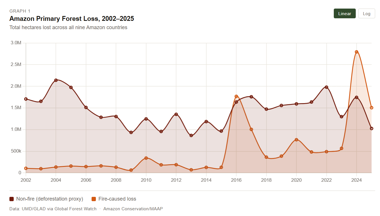
In 2025, fires caused 1.51 million hectares (3.7 million acres) of forest loss — down from the 2.79 million hectares (6.9 million acres) lost in 2024, when dry El Niño conditions worsened fires. It was the third-highest total since 2002.
Researchers pointed out that the numbers are concerning even if they don’t represent complete forest loss. Fires aren’t part of the natural ecosystem in tropical forests, and recovery can take much longer than expected due to climate change and repeated burning in the same areas, they said.
“We know that once forests burn once, they’re more susceptible to burning again,” said Elizabeth Goldman, co-director of Global Forest Watch, a platform that hosts forest loss data. “And if the fires continue to have repeated impacts on forests, it’s possible that they might not actually recover.”
The rest of the data, labeled as “non-fire” forest loss, is considered a better proxy for understanding human-driven deforestation. According to the analysis, 2025 had one of the lowest non-fire forest loss figures in a decade and the fifth lowest since 2002, totaling 1.03 million hectares (2.54 million acres).
In previous years, it was nearly twice as high, hitting 1.47 million hectares (3.6 million acres) in 2018 and climbing to 1.98 million hectares (4.9 million acres) in 2022.
The drop is good news, but it still represents a significant loss that should be worrying, researchers said.
“We should be learning lessons from that success, I think, but at the same time acknowledging that it’s still not enough,” Goldman said.
Landslides, windstorms, meandering rivers and other occurrences are often mistakenly registered as primary forest loss in the non-fire data. This year, the MAAP analysis provided an even more specific estimate for deforestation that removed some of those factors.
The estimate puts 2025 deforestation at 736,484 hectares (1.8 million acres), 94.6% of it from agriculture and 5.3% of it from hard commodities like gold mining, with the remaining 0.1% caused by roads and infrastructure.
Nearly 132,000 hectares (326,179 acres) of it was illegal, occurring inside protected areas and Indigenous territories, the analysis found.
Finer with MAAP stressed the importance of roads and infrastructure even though they’re dwarfed by agriculture in the data. Roads themselves only clear a small section of the forest but tend to provide new access for agribusiness, as seen in Brazil around the Trans-Amazonian Highway and BR-364.
Mining might also look small in the data but has an outsized impact in protected areas and Indigenous territory, he said. It accounts for 11% of the deforestation inside those areas.
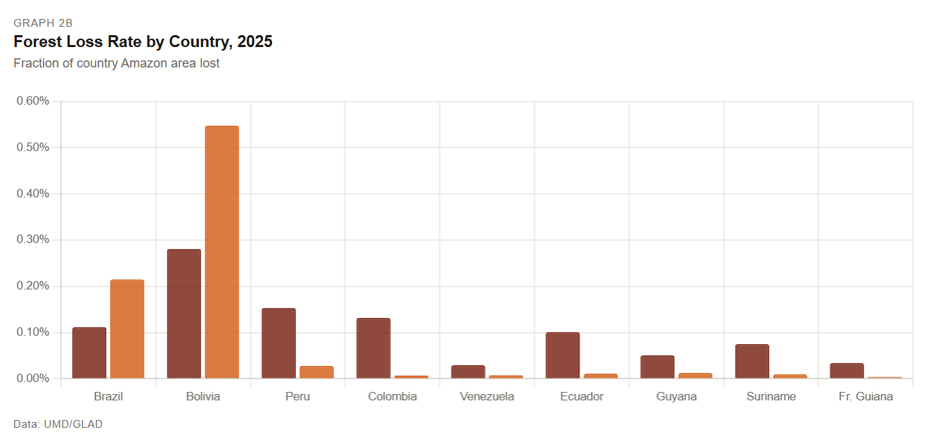
The MAAP analysis also found that more than half of the deforestation occurred in Brazil, followed by Peru, Bolivia and then Colombia.
In the data, Brazil looks like the leader in almost every metric. But when standardized for area, Bolivia leads on fire-driven forest loss and non-fire primary forest loss, most notably from the expanding soy frontier in the Santa Cruz department.
“Bolivia really starts to emerge as the place with the highest deforestation and fire rates per area,” Finer said.
Researchers said forest loss in 2026 might look considerably different from last year, as the current El Niño continues to warm up the Pacific Ocean, creating heat waves and dry conditions that could lead to more forest fires.
One solution to exacerbated climate events like El Niño is to create better climate policy, which can only happen if the right leaders are in office, Goldman said. That includes leaders not just in forested countries, she noted, but across the globe.
“The way that we need to enact change in the future is by electing leaders that care about the forest, that care about the environment,” Goldman said.
Banner image: Deforestation from an Indigenous cattle pasture in Formoso do Araguaia, Tocantins state, Brazil. (AP Photo/Andre Penner)
See related from this reporter:
New Jaguar Rivers Initiative aims to reconnect South America’s fragmented ecosystems
FEEDBACK: Use this form to send a message to the author of this post. If you want to post a public comment, you can do that at the bottom of the page.
Credits
This story first appeared on Mongabay
This article is licensed under a Creative Commons Attribution-NoDerivatives 4.0 International License.
You may republish this article, so long as you credit the authors and Mongabay, and do not change the text. Please include a link back to the original article.